AniMap 3.0

AniMap is a county boundary historical atlas for Windows
5 
Rating
Your vote:
Latest version:
3.0.2 See all
Developer:
Adrian B. Ettlinger
Screenshots
1 / 1
Shareware
Request
Download
link when available

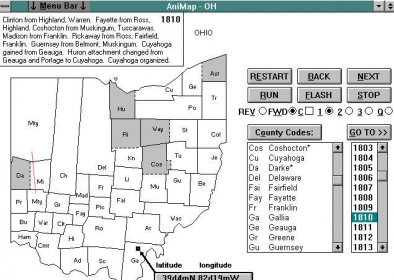
AniMap is a county boundary historical atlas for Windows.
Just about every researcher deals with the problem of finding an old town that has long-since disappeared from the map. Or, you have a known location but it was not in the same county 100 or 200 years ago. This application now has solutions to these problems.
It can display over 2,300 maps in color to show the changing county boundaries for each of the 48 adjacent United States for every year since colonial times.

Comments (2)

User

Your vote:

D
rating dawn Sisk Holloway
I refer to this program often when I run across families moving (or looks like they have moved) when boundaries change. Helps with verification.

Sep 14, 2021 Was it helpful?  yes(0) no(0) | Reply
C
rating Charles William Meiser
I have been an AniMap user for over a decade. It is invaluable in my genealogical research because places rarely move, but boundaries do, especially years ago.

Aug 18, 2021 Was it helpful?  yes(0) no(0) | Reply